Latitude and longitude are geographical coordinates that help us identify specific locations on Earth. These coordinates are crucial for navigation and understanding the Earth’s geography. Learning latitude and longitude can be a challenging concept for students, but worksheets can provide an interactive and engaging way to grasp this topic.
Latitude represents the distance north or south of the equator, while longitude represents the distance east or west of the prime meridian. Understanding how latitude and longitude work together can help us locate places accurately on a map. Worksheets with answers can facilitate this learning process by providing practice exercises and solutions.
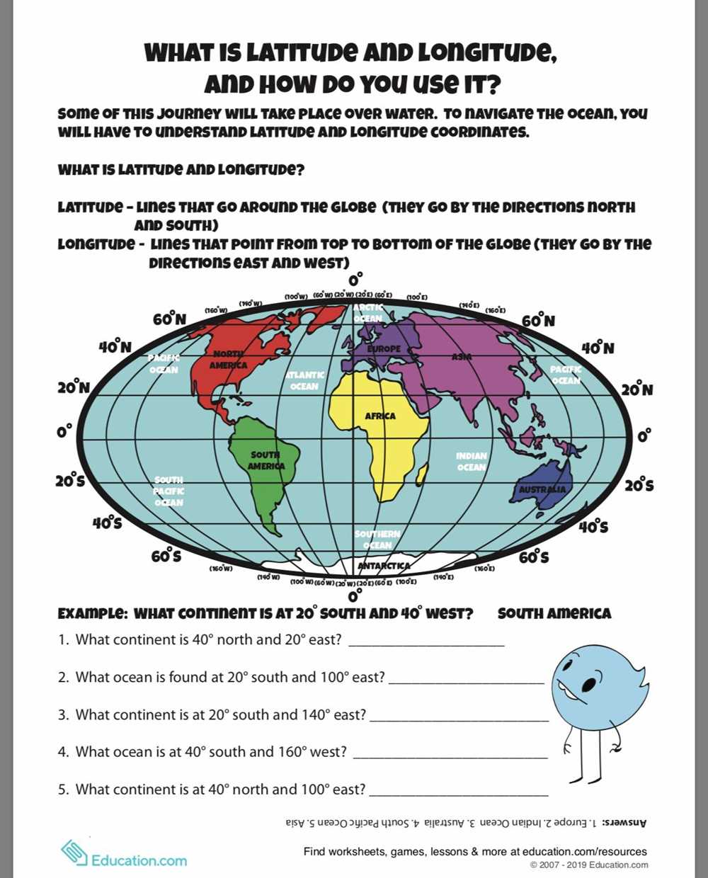
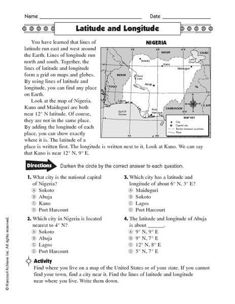
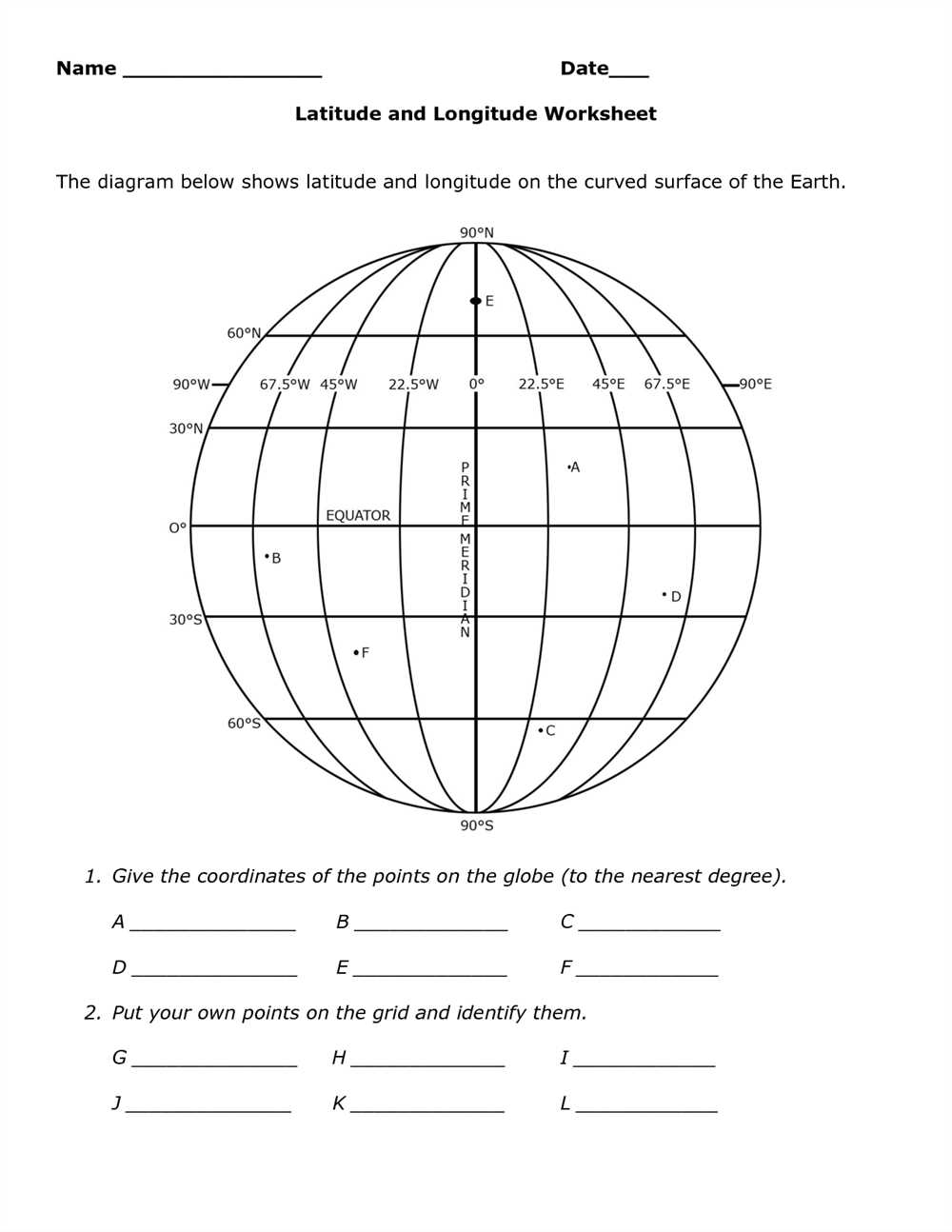
These latitude and longitude worksheets with answers typically include map activities, where students are given coordinates and asked to identify the corresponding location. They may also involve identifying latitude and longitude lines on a map or using latitude and longitude to solve real-world problems, such as determining the coordinates of famous landmarks or calculating distances between two points.
By completing these worksheets, students can improve their geographic literacy and develop essential skills in reading and interpreting maps. They can also enhance their critical thinking and problem-solving abilities, as latitude and longitude often require spatial reasoning. With the help of worksheets with answers, students can gain a solid understanding of latitude and longitude and enhance their overall geography knowledge.
Understanding Latitude and Longitude

Latitude and longitude are two important geographic coordinates that are used to pinpoint and locate places on the earth’s surface. They provide a global system for navigation and are essential for mapping, travel, and communication purposes. Latitude measures the distance north or south of the equator, while longitude measures the distance east or west of the prime meridian.
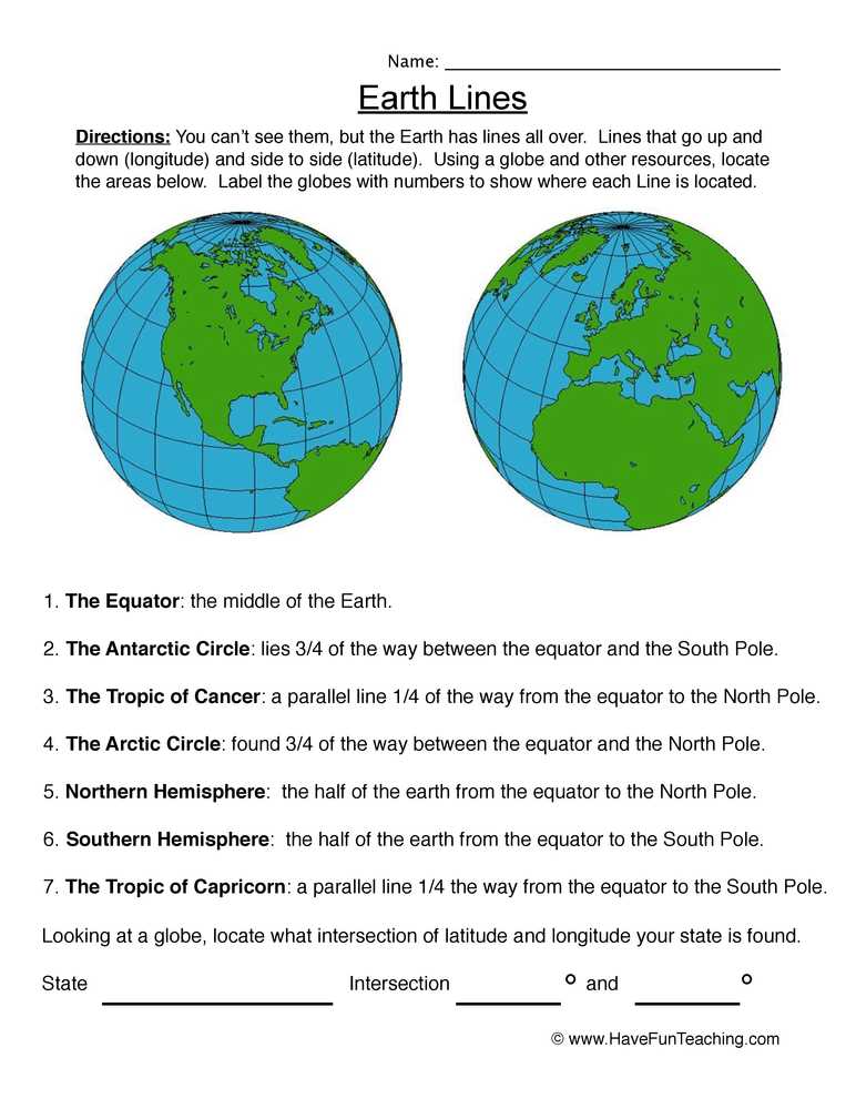
Latitude, also known as parallels, are horizontal lines that run east-west around the globe. They are measured in degrees, with 0 degrees at the equator and 90 degrees at the North and South Poles. The equator is the reference point for measuring latitude and divides the earth into the Northern and Southern Hemispheres. The latitude lines help determine the climate and temperature variations across different regions of the world.
Longitude, also known as meridians, are vertical lines that run north-south around the globe. They are also measured in degrees, with 0 degrees at the prime meridian, which passes through Greenwich, London. The prime meridian serves as the reference point for measuring longitude and divides the earth into the Eastern and Western Hemispheres. Longitude lines help in determining the local time and are crucial for navigation and timekeeping purposes.
When combined, latitude and longitude form a grid system that allows for precise location determination. Each point on the earth’s surface has a unique set of coordinates that can be represented using degrees, minutes, and seconds. For example, a specific point in New York City can be represented as 40° 45′ N latitude and 73° 58′ W longitude.
Understanding latitude and longitude is essential for various disciplines, including geography, cartography, and navigation. It enables us to locate specific places, calculate distances, and navigate accurately around the world. By using latitude and longitude, we can easily communicate and share information about specific locations in a standardized format that is universally understood.
What are latitude and longitude?

Latitude and longitude are geographic coordinates that help us identify and locate places on Earth. They provide a universal system for pinpointing specific points on the globe, allowing for accurate navigation and communication.
Latitude refers to the imaginary lines that run horizontally around the Earth, parallel to the Equator. It is measured in degrees, minutes, and seconds, with the Equator representing 0 degrees latitude. The lines above the Equator are described as being in the Northern Hemisphere, while those below the Equator are in the Southern Hemisphere. The maximum latitude is 90 degrees at both poles.
Longitude, on the other hand, refers to the imaginary lines that run vertically from the North Pole to the South Pole, passing through the poles and intersecting the Equator. It is also measured in degrees, minutes, and seconds, with the Prime Meridian (which runs through Greenwich, London) representing 0 degrees longitude. The lines to the east of the Prime Meridian are described as being in the Eastern Hemisphere, while those to the west are in the Western Hemisphere.
By combining latitude and longitude, we are able to precisely identify any location on Earth. For example, the coordinates of New York City are approximately 40.7128 degrees latitude and -74.0060 degrees longitude. These coordinates allow us to plot the exact position of New York City on a map or navigate to it using, for instance, a GPS device.
Why are latitude and longitude important?
Latitude and longitude are vital geographic coordinates that help us locate and identify places on the Earth’s surface. They provide a precise way to measure and describe locations in terms of their distance from the Equator (latitude) and the Prime Meridian (longitude).
1. Navigation and Mapping: Latitude and longitude play a crucial role in navigation and mapping. They help pilots, sailors, and travelers determine their exact position and chart their course. These coordinates are used in global positioning systems (GPS) to guide vehicles and individuals to their desired destinations accurately and efficiently. They also help mapmakers create detailed maps that accurately represent the Earth’s features and provide essential information for exploration, research, and planning.
2. Time Zone Determination: Latitude and longitude are used to define time zones around the world. The Earth is divided into 24 time zones, each approximately 15 degrees of longitude wide. By knowing the longitude of a specific location, we can determine the local time accurately. This is crucial for scheduling international travel, coordinating global business operations, and ensuring accurate timekeeping.
3. Climate and Weather Analysis: Latitude and longitude influence climate and weather patterns. Different latitudes experience variations in sunlight, temperature, and rainfall due to the Earth’s curvature and its tilt towards the sun. Meteorologists use latitude and longitude to analyze and forecast weather conditions accurately, track storms, and monitor climate change.
4. Geographical Research and Studies: Latitude and longitude provide a universal system for geographers, researchers, and scientists to precisely describe and analyze locations around the globe. They help identify patterns, track changes over time, measure distances, and compare different regions. This information is valuable for studying physical and human geography, land use planning, environmental conservation, and urban development.
In conclusion, latitude and longitude are critical elements of geographic information systems. They enable accurate navigation, time zone determination, climate analysis, and geographical research. Understanding and utilizing these coordinates are fundamental for various fields and activities that require precise spatial information.
What are latitude worksheets?
Latitude worksheets are educational materials designed to help students learn and practice their understanding of latitude and longitude. These worksheets typically consist of exercises and activities that require students to identify and locate points on the Earth’s surface using latitude and longitude coordinates.
One common type of latitude worksheet is a map-based exercise, where students are given a map and asked to locate specific points using latitude and longitude coordinates. These exercises help students develop their map-reading skills and improve their knowledge of latitude and longitude.
Latitude worksheets often include:
- Exercises that require students to identify the latitude and longitude coordinates of specific cities or landmarks.
- Activities that involve calculating the distance between two points on the Earth’s surface using latitude and longitude coordinates.
- Questions and prompts that encourage students to think critically about the relationship between latitude, climate, and the Earth’s physical features.
Using latitude worksheets can be an effective way for students to practice and reinforce their understanding of latitude and longitude. These worksheets provide an interactive and engaging way for students to learn about the Earth’s coordinate system and develop their geography skills.
How are latitude worksheets helpful?
Latitude worksheets are an essential tool for teaching and learning about geography and navigation. These worksheets provide students with the opportunity to practice and reinforce their understanding of latitude, which is crucial for locating and navigating places on the Earth’s surface.
1. Enhances knowledge: Latitude worksheets allow students to deepen their knowledge and comprehension of latitude, helping them understand the concept better. By practicing with worksheets, students can grasp the ways latitude is measured and understand its significance in identifying a location’s position.
2. Develops map-reading skills: Latitude worksheets help develop students’ map-reading skills as they require them to interpret geographic coordinates and locate places accurately. By working on these worksheets, students are exposed to various scenarios that require them to identify latitude and determine the distance between different locations.
3. Encourages critical thinking: Latitude worksheets often include questions that require students to think critically and apply their knowledge to solve problems. They may need to analyze a given latitude value and determine the corresponding location or calculate the distance between two points based on latitude. This helps students develop problem-solving skills and enhances their analytical thinking abilities.
4. Reinforces spatial awareness: Latitude worksheets help reinforce students’ spatial awareness by requiring them to visualize the Earth’s surface and understand the impact of latitude on the distribution of climate zones, daylight hours, and other geographical phenomena. This strengthens their understanding of global patterns and facilitates a deeper comprehension of Earth’s geography.
In conclusion, latitude worksheets play a vital role in enhancing students’ understanding of latitude, developing their map-reading skills, encouraging critical thinking, and reinforcing spatial awareness. By using these worksheets, educators can make the learning process more engaging and effective, ensuring that students develop a solid foundation in geography and navigation.
Beginner Level Latitude Worksheets

Latitude and longitude are essential concepts in geography and understanding them is crucial for any beginner to the subject. To help students grasp these concepts, the use of latitude worksheets can be highly beneficial. These worksheets provide exercises and activities that allow students to practice and improve their understanding of latitude.
One type of beginner level latitude worksheet is the fill-in-the-blank format. In this type of worksheet, students are given a map with a series of coordinates indicated by latitude and longitude. Their task is to fill in the missing latitude or longitude for each coordinate. This not only helps students practice identifying coordinates on a map but also reinforces their understanding of how latitude and longitude work.
Another type of beginner level latitude worksheet is the matching format. In this type of worksheet, students are given a list of locations and corresponding latitude and longitude coordinates. Their task is to match each location with its correct coordinates. This exercise helps students develop their critical thinking skills as they need to analyze the relationship between location and coordinates.
For a more interactive learning experience, beginner level latitude worksheets can also incorporate group activities. Students can work together to solve latitude-based puzzles or engage in treasure hunts using coordinates. These activities not only make learning fun but also encourage students to collaborate and communicate with their peers.
By using beginner level latitude worksheets, educators can effectively introduce and reinforce the concepts of latitude and longitude to their students. These worksheets provide a structured and engaging way for students to practice and improve their understanding of this essential geographical knowledge.
Identifying latitude coordinates on a map

Latitude coordinates are an essential component of map reading and navigation. They help us determine the location of a point on the Earth’s surface in relation to the equator. Latitude is measured in degrees, with values ranging from 0° at the equator to 90° at the North and South poles.
To identify latitude coordinates on a map, you need to understand how the lines of latitude are drawn. These lines, also known as parallels, run parallel to the equator. They are evenly spaced and numbered from 0° to 90°, with the equator at 0°, the North Pole at 90°N, and the South Pole at 90°S.
For example, if you are given a latitude coordinate of 40°N, you can locate it on the map by finding the line of latitude that is labeled 40°N. This line will be located approximately halfway between the equator and the North Pole. By following this line horizontally across the map, you can pinpoint the specific latitude coordinate.
Latitude coordinates are often used in conjunction with longitude coordinates to provide precise locations on a map. Together, these coordinates help us navigate and understand the world around us.
Finding latitude using landmarks
Latitude is an important coordinate that helps us locate places on the Earth’s surface. One way to determine latitude is by using landmarks. Landmarks are distinctive features or points of reference that can be easily identified on a map or in real life. By knowing the latitude of a specific landmark, we can then determine the latitude of other locations nearby.
When using landmarks to find latitude, we need to consider a few key factors. First, we should identify a well-known landmark that has a known latitude. For example, the Eiffel Tower in Paris, France has a latitude of approximately 48.8584 degrees north. Once we have this reference point, we can use it to estimate the latitude of other locations in the surrounding area.
To find the latitude of a specific location using landmarks, we can use tools such as a compass, a protractor, or even online mapping applications. By measuring the angle between the landmark and the horizon, we can calculate the latitude using trigonometric principles. This method requires some basic knowledge of mathematics and geometry, but it can be a fun and engaging way to learn about latitude and how it is measured.