
When it comes to studying earthquakes, one of the most important aspects is locating their epicenters. This process involves the analysis of seismic waves recorded at various seismographic stations. By carefully analyzing the arrival times of these waves, scientists can determine the epicenter of an earthquake and gain valuable insights into the Earth’s structure and plate tectonics.
In the lab activity of locating an earthquake epicenter, students are presented with data from three seismographic stations, each at a different distance from the epicenter. Using the arrival times of primary (P) and secondary (S) waves recorded at each station, students are tasked with determining the time difference between these two waves.
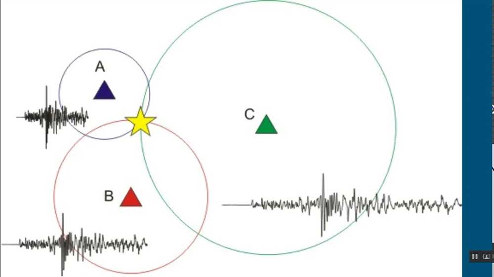
By calculating the time difference between the P and S waves, students can determine the epicenter distance from each station. This information is then used to construct circles around each seismographic station, with their radius equal to the epicenter distance. The point where these circles intersect represents the location of the earthquake epicenter. Through this hands-on activity, students gain a deeper understanding of the scientific methods used to locate earthquake epicenters and the importance of accurate data analysis.
What is an earthquake epicenter?
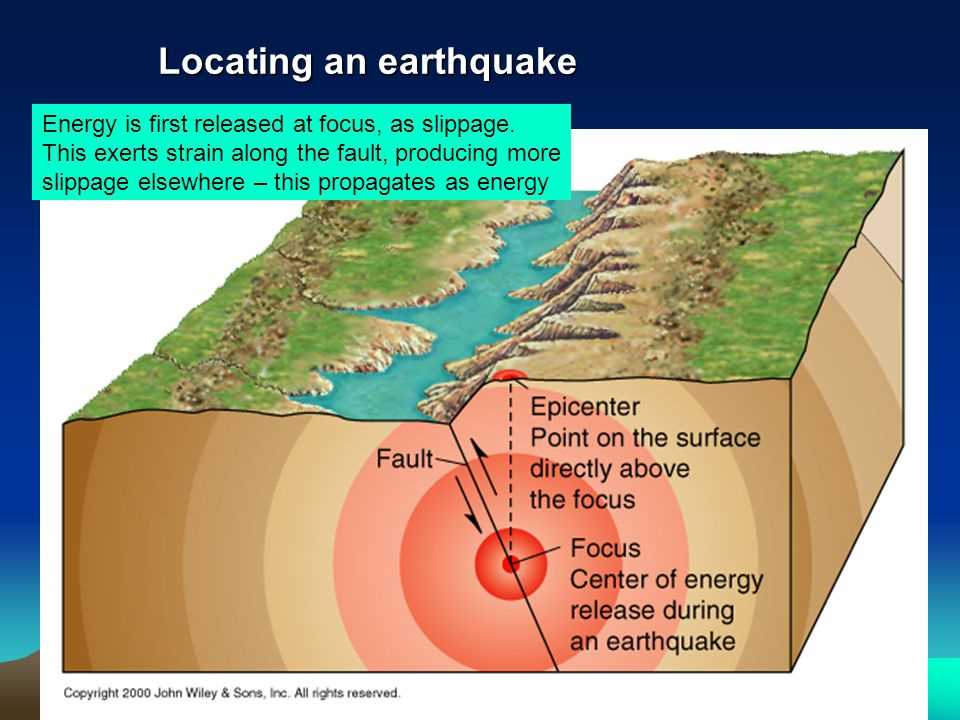
An earthquake epicenter is the point on the Earth’s surface directly above the hypocenter or focus, which is the location where an earthquake originates. It is the place where the seismic waves, which cause the shaking during an earthquake, first reach the surface. Identifying the epicenter is an important task in seismology as it helps determine the location and magnitude of an earthquake, which in turn can assist in understanding the tectonic activity and seismic hazards in a particular region.
Scientists use various techniques to locate an earthquake epicenter. One method is by analyzing the arrival times of seismic waves at different seismograph stations. By measuring the time it takes for these waves to reach multiple stations, scientists can triangulate the epicenter. Another technique involves using the differences in arrival times of the P-waves and S-waves, which travel at different speeds, to determine the distance between the epicenter and the stations.
- Seismic Waves: Seismic waves are vibrations that spread out from the earthquake’s focus and travel through the Earth’s interior.
- Seismograph Stations: These are devices that record the ground motion caused by seismic waves. By analyzing the data from multiple stations, scientists can gather the necessary information to locate an epicenter.
- P-waves: Also known as primary waves, these are the first type of seismic waves to arrive at a seismograph station. They are compressional waves that travel faster than S-waves.
- S-waves: Also known as secondary waves, these are the second type of seismic waves to arrive at a seismograph station. They are shear waves that travel slower than P-waves.
Knowing the precise location of an earthquake epicenter is crucial for emergency response and preparedness measures. It helps authorities assess the extent of the damage, plan evacuation routes, and allocate resources effectively. Additionally, studying epicenters and patterns of earthquake occurrence can provide valuable insights into the Earth’s tectonic processes and help scientists better understand and predict future seismic events.
Why is locating an earthquake epicenter important?
Locating the epicenter of an earthquake is crucial for understanding and predicting seismic activity. By determining the exact location of an earthquake’s epicenter, scientists can analyze the data and gain insights into the underlying geologic processes and tectonic activities. This information is vital for assessing the hazards associated with earthquakes and developing strategies to mitigate their impacts.
One of the key reasons why locating an earthquake epicenter is important is because it helps in calculating the magnitude of the earthquake. By studying the seismic waves recorded at multiple stations, scientists can triangulate the data to pinpoint the epicenter and determine the amount of energy released during the event. This information is essential for assessing the strength of the earthquake and its potential to cause damage to infrastructure and endanger human lives.
Additionally, locating the epicenter enables scientists to study the patterns and distribution of earthquakes over time. By analyzing the data from various earthquakes, researchers can identify seismically active regions and understand the underlying geological structures that contribute to seismic activity. This knowledge can aid in the development of earthquake hazard maps and assist in making informed decisions about land use planning and construction practices in earthquake-prone areas.
Furthermore, precise epicenter locations are crucial for effective earthquake early warning systems. By accurately determining the epicenter, seismic monitoring networks can quickly assess the intensity and possible impacts of an earthquake, allowing authorities to activate early warning systems and initiate emergency response measures. This can save lives and minimize damage by providing valuable seconds to minutes of advance warning before the arrival of strong shaking.
In conclusion, locating an earthquake epicenter is of paramount importance for understanding seismic activity, calculating earthquake magnitudes, studying earthquake patterns, and implementing effective early warning systems. The ability to accurately locate epicenters allows scientists and authorities to better understand and mitigate the risks associated with earthquakes, ultimately leading to safer and more resilient communities.
The process of locating an earthquake epicenter
An earthquake epicenter is the point on the Earth’s surface directly above the focus or origin of an earthquake. Determining the exact location of an earthquake epicenter is crucial for understanding the tectonic activity and potential seismic hazards in a region. Scientists use a variety of techniques and instruments to accurately locate an earthquake epicenter.
Seismic waves: When an earthquake occurs, it produces seismic waves that propagate through the Earth’s layers. These waves can be detected and recorded by seismographs, which are sensitive instruments that measure ground motions. The recorded seismograms provide important information about the arrival times of different waves and their amplitudes at seismograph stations located at various distances from the epicenter.
Triangulation: To locate the epicenter, scientists need data from at least three seismograph stations. By comparing the difference in arrival times of specific seismic waves at these stations, scientists can determine the distance of each station from the epicenter. This information allows them to create three circles or arcs on a map, with each station representing the center of a circle. The intersection of these circles provides an estimate of the earthquake epicenter’s location.
Secondary waves: Scientists also use the arrival times of secondary or S-waves (shear waves) to further refine the location of the epicenter. S-waves travel slower than primary waves (P-waves) and do not travel through liquids, such as the Earth’s outer core. By identifying the arrival times of S-waves on seismograms, scientists can determine the distance from each station to the epicenter more precisely.
Seismic network: To improve the accuracy and speed of locating earthquake epicenters, scientists have established global and regional seismic networks. These networks consist of numerous seismograph stations strategically placed around the world. The data collected from these stations are shared and analyzed to quickly determine the location of earthquake epicenters. This collaborative effort allows scientists to monitor seismic activity and provide timely information for earthquake response and hazard mitigation efforts.
In conclusion
Locating an earthquake epicenter is a complex process that involves analyzing the data collected from seismograph stations, using triangulation techniques, and considering the properties of seismic waves. By accurately determining the epicenter, scientists can better understand the earthquake’s origin, magnitude, and potential hazards. This information is crucial for assessing seismic risks and developing strategies to minimize the impact of future earthquakes.
Collecting Earthquake Data
When studying earthquakes, collecting accurate and precise data is crucial for analyzing and understanding these natural phenomena. Scientists and seismologists use various instruments and techniques to gather data on earthquakes, helping them determine the location, magnitude, and other characteristics of these seismic events.
One of the primary instruments used in collecting earthquake data is a seismograph. This device measures the ground motion caused by an earthquake and records the resulting seismic waves. It consists of a drum or a digital sensor that moves in response to ground motion and a pen or needle that records the movement on a rotating drum or a computer screen. By analyzing the recorded data, scientists can determine the timing, duration, and amplitude of the seismic waves.
Another important technique in collecting earthquake data is the use of networks of seismographic stations. These stations are strategically located around the world to provide comprehensive coverage of earthquake activity. Each station measures the ground motion independently, and by comparing the recorded data from multiple stations, scientists can triangulate the epicenter of an earthquake. This information is essential for understanding the geographic distribution and pattern of seismicity.
In addition to seismographs and seismographic networks, scientists also collect earthquake data through GPS (Global Positioning System) measurements, satellite remote sensing, and geological surveys. These techniques provide valuable information about the movement and deformation of the Earth’s crust, helping scientists monitor seismic activity, identify earthquake-prone areas, and study the processes that lead to earthquakes.
In conclusion, collecting earthquake data involves the use of seismographs, seismographic networks, GPS measurements, satellite remote sensing, and geological surveys. These tools and techniques enable scientists to analyze and interpret seismic events, providing valuable insights into the Earth’s dynamics and helping mitigate the risks associated with earthquakes.
Triangulation Method
The triangulation method is a technique used to determine the location of an earthquake epicenter by measuring the arrival times of seismic waves at three or more seismograph stations. By comparing the arrival times of P-waves and S-waves at different stations, scientists can calculate the distance between each station and the epicenter.
In order to use the triangulation method, seismographs must be strategically placed around the globe to ensure accurate measurements. These stations, equipped with sensitive instruments, detect and record the vibrations caused by seismic waves. When an earthquake occurs, the waves radiate out from the epicenter and are detected by the seismographs.
- P-waves: Primary waves that are the first to arrive at a seismograph station. These waves travel the fastest and can travel through both solids and liquids.
- S-waves: Secondary waves that arrive after P-waves. These waves travel slower than P-waves and can only travel through solids.
By analyzing the time differences between the arrival of P-waves and S-waves at multiple stations, scientists can determine the distance from each station to the epicenter. This information is then used to draw circles around each station, with the radius representing the distance to the epicenter. The point where the circles intersect is the estimated location of the earthquake epicenter.
The triangulation method is an important tool in earthquake monitoring and research, as it allows scientists to accurately locate seismic events. This information is crucial for understanding earthquake patterns, assessing the risk in different regions, and developing strategies for earthquake preparedness and response.
Using seismographs
Seismographs are essential tools used in the study of earthquakes and the determination of their epicenters. These instruments measure the vibrations caused by seismic waves, which are generated by the release of energy during an earthquake. By recording the time it takes for seismic waves to travel from the earthquake source to different locations around the world, seismographs help scientists locate and identify earthquake epicenters.
Seismographs consist of a heavy weight suspended from a frame that is anchored to the ground. When an earthquake occurs, the ground beneath the seismograph shakes, causing the weight to remain stationary due to inertia while the frame moves with the ground. This relative motion is converted into a graphical representation by a recording device attached to the weight. The resulting seismogram shows the amplitude and duration of the seismic waves and provides valuable information about the characteristics of the earthquake.
Seismographs are strategically placed around the world to ensure comprehensive monitoring of seismic activity. Information from different seismographs is collected and analyzed to determine the location, magnitude, and depth of an earthquake. By comparing the arrival times of P-waves and S-waves recorded at different seismograph stations, scientists can calculate the distance between each station and the earthquake epicenter. With data from at least three seismographs, they can triangulate the epicenter and accurately pinpoint its location.
Key Points:
- Seismographs measure vibrations caused by seismic waves.
- Seismic waves are generated by the release of energy during an earthquake.
- Seismographs help locate and identify earthquake epicenters.
- Seismograms show the amplitude and duration of seismic waves.
- Multiple seismographs are used to triangulate the epicenter of an earthquake.
Understanding earthquake waves
An earthquake is a natural phenomenon characterized by the shaking of the Earth’s surface. It is caused by the release of energy in the Earth’s crust, resulting in seismic waves. These waves propagate through the Earth and can be classified into two main types: body waves and surface waves.
Body waves are the first to be generated during an earthquake and they travel through the interior of the Earth. There are two types of body waves: primary (P) waves and secondary (S) waves. P-waves are the fastest seismic waves and they travel through solids, liquids, and gases. They cause the particles of the material they pass through to compress and expand in the direction of wave propagation. S-waves, on the other hand, are slower than P-waves and can only propagate through solids. They cause particles to move perpendicular to the direction of wave propagation.
Surface waves, as the name suggests, travel along the Earth’s surface. They are slower than body waves but are responsible for causing the most damage during an earthquake. There are two types of surface waves: Love waves and Rayleigh waves. Love waves move in a horizontal, side-to-side motion and can cause buildings and structures to sway. Rayleigh waves, on the other hand, move in an elliptical motion, causing the ground to ripple up and down, which can result in liquefaction and landslides.
Understanding earthquake waves is crucial for locating the epicenter of an earthquake. By analyzing the arrival times of P-waves and S-waves at different seismic stations, scientists can determine the distance from each station to the epicenter. This information, combined with data from other stations, can then be used to triangulate the exact location of the earthquake epicenter.